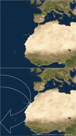
 Over the Equator, hot air masses rise to the atmosphere’s upper layers. Driven by convection towards the North Pole’s colder temperatures, they are subsequently deviated clockwise by the earth's rotation. This happens at around 30° latitude over the Atlantic Ocean. Upon sinking and cooling, a high pressure area (Anticyclone) centered on the Azores islands is created.
Unlike local winds influenced by topography, Atlantic ‘trade winds’ are global and perpetual as long as our planet rotates while exposed to solar radiation.
Trade winds have been used for centuries. Their pathways impacted sailing routes and led to European empire-building, upsetting the balance of powers, resulting in free or forced human migrations. Being at the origin of today’s globalized world, they also influenced most of its political geography.
Shaping Atlantic surface currents by wind shear in similar pathways, trade winds have been active for millions of years. This can be attested by geological records provided by the world’s largest sedimentary phosphate deposits (68% of World reserves*) trapped in North Africa’s coastal plains.
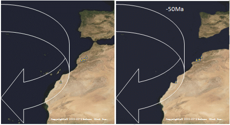
Pushed by trade wind-induced currents, massive amounts of plankton kept drifting towards North Africa's shallow shores. Combined with phosphorus-rich cold waters from deeper ocean levels brought to the surface, their concentration attracted an exceptionally rich biotope whose remains accumulated in the area 70 to 40 Million years ago.
 Built-up during the Paleocene and Eocene geological era, their remains phosphatized through a lengthy mineralization process. Identified by yellow triangles on the animated map (over Khouribga, Benguérir, Youssoufia and Boucrâa), they represent today's largest known commercially mined phosphate-rock deposits.
Further South, at the junction between the Atlantic Ocean and the Sahara desert, trade winds merge with African shores in a global energy exchange zone dominated by a dry climate and steady winds. Generated over the Sahara's hot surfaces, daily thermal air streams complement oceanic trade winds blowing on the Sahara coastline. This produces one of the world’s largest on-shore wind resources.
By moving away clouds arriving from the ocean, trade winds are responsible for the Sahara's extreme dryness. Their North to North-East wind directions, resulting from the merging of global and local effects, shaped the majority of the Saharan coastline into vast inert rocky plateaus, called "Hammadas".


